THE AWE INITIATIVE
™  ·  UNIFIED SAFETY & SECURITY PLATFORM

Fusing every signal into one control room.

The AWE Initiative brings identity, community intelligence, geospatial data and AI into a single unified platform — built on fusion, layered security, big data, transparency, engagement and accountability.

Scroll to explore ↓
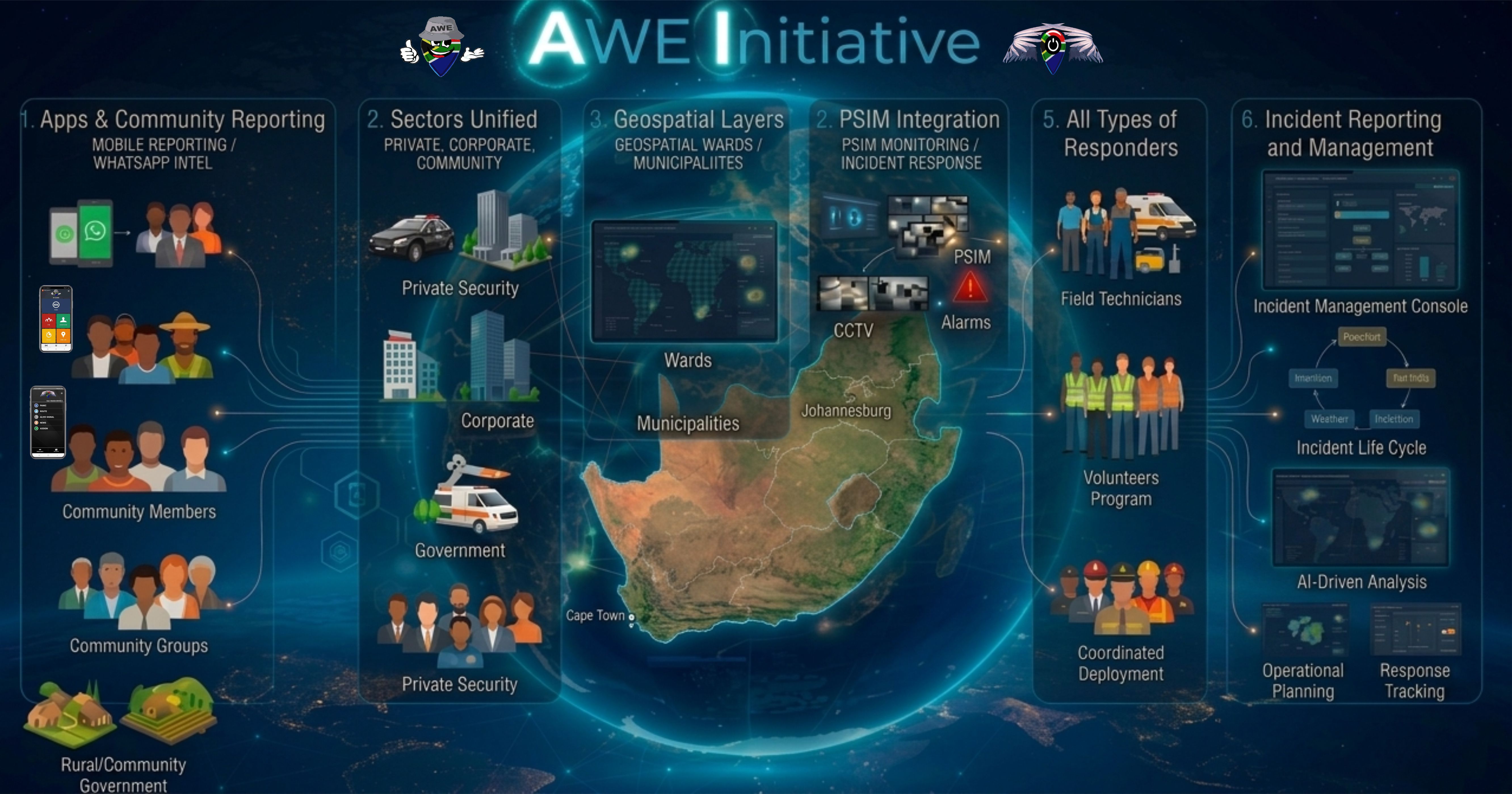
The AWE Initiative ecosystem diagram

One ecosystem — from citizen and community reporting through geospatial context, PSIM integration and responder coordination, to AI-driven incident management.

The AWE Philosophy

Six principles behind every module

AWE isn't a single tool bolted onto another — it's a platform designed from the ground up around six ideas that shape every feature, workflow and report.

🔗
Fusion
Every signal — a face, a plate, a WhatsApp message, a perimeter trigger, a patrol GPS point — resolves into one shared event record, not six disconnected systems.
🛡️
Layered Security
Identity, community signal, geospatial context and AI orchestration stack together, so a credible threat pattern emerges long before a single alarm ever could.
📊
Big Data
Millions of messages, sightings and sensor triggers are classified and structured automatically — turning raw noise into searchable, decision-ready intelligence.
🔍
Transparency
Every AI classification, dispatch decision and responder action is logged and auditable — nothing about how an outcome was reached is a black box.
🤝
Engagement
Citizens, communities, responders and control rooms all participate in the same system — reporting, responding and staying informed from one shared platform.
Accountability
Response times, patrol compliance and incident outcomes are measured and reportable on demand — proof of service, not just a promise of it.

How It All Connects

One ecosystem, wrapped around every operation

From the first report on a citizen's phone to the incident closed out in the control room, every layer feeds the same operating picture.

📱
Apps & Community Reporting
Mobile reporting and WhatsApp intelligence from citizens, volunteers and staff.
🏢
Sectors Unified
Private security, corporate, government and community, on one platform.
🗺️
Geospatial Layers
Wards, municipalities and sites mapped and geofenced for full context.
📹
PSIM Integration
Cameras, alarms and perimeter sensors feeding straight into response.
🧑‍✈️
Responder Management
Field technicians, volunteers and armed response, coordinated as one.
📊
Incident Reporting & Management
AI-driven analysis, operational planning and full response tracking.
Explore

Where would you like to start?

Two ways into The AWE Initiative — see how it fits your industry, or dig into the full admin platform module by module.

See it running for your operation.

Book a demo built around your actual security operation — we'll show you exactly how it fits what you're running today.

Book a Demo →